
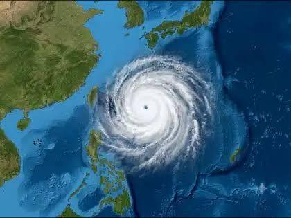
According to the United States National Weather Service, Champi was located in the western Pacific on Wednesday, 21 October, moving west-north-west at approximately 17 miles per hour. Its sustained winds reached 185 miles per hour, placing it in the equivalent of Category Five intensity on the Saffir–Simpson hurricane scale. Forecasters expect the storm to begin weakening, although it remains exceptionally powerful. <Cite refs={["turn951263search1","turn951263search0"]}/>
The storm developed over warm Pacific waters, where favourable atmospheric conditions helped it intensify rapidly. Its strength highlights the destructive potential of tropical cyclones in the region, particularly when strong winds combine with torrential rainfall, dangerous seas and storm-related flooding.
Weather authorities in Japan are closely monitoring Champi as it approaches the country's southern island chains. The Japan Meteorological Agency has warned that the storm could affect Okinawa's Sakishima Islands between Friday and Saturday, with possible impacts extending towards western Japan and parts of Kyushu. Residents have been urged to follow official forecasts and prepare for potentially hazardous weather. <Cite refs={["turn951263search2","turn951263search8"]}/>

The Economic Times
Taiwan is also within the broader area being monitored as the storm tracks north-westwards. However, the exact path and intensity of Champi may change, and its current forecast does not mean that every location along its projected route will experience the storm's strongest winds. Authorities will continue updating forecasts as new observations become available.
The main threats associated with a storm of this strength include destructive winds, heavy rainfall, flash flooding, landslides in vulnerable areas and dangerous coastal conditions. Even if Champi weakens before approaching land, its large circulation could still produce hazardous weather across affected islands and coastal communities.
As Champi continues across the Pacific, emergency agencies and residents in potentially affected areas are being advised to monitor official warnings, secure loose outdoor objects and prepare for possible travel disruption. The storm's future path and intensity will determine the extent of any impacts, but forecasters say caution remains necessary while the system is still exceptionally strong.